
Liberty Star CEO / Chief Geologist James A. Briscoe: Exploration of East & West Silverbell from 1990 to 2000 & the creation of Ironwood Forest National Monument
|
By Allen Alper, Jr., President of Metals News
on 7/7/2017
Liberty Star Uranium & Metals Corp. (LBSR: OTCBB) (LBSR: OTCPK) is an Arizona-based mineral
exploration company engaged in the acquisition, exploration, and development of mineral properties in
Arizona and the southwest USA. Currently the company controls properties which are located over what
management considers some of North America’s richest mineralized regions for copper, gold, silver,
molybdenum (moly), and uranium.
Jim Briscoe is the Founder, CEO and Chief Geologist of Liberty Star and is a Professional Geologist,
registered in Arizona and California. He is an expert on porphyry copper systems and has decades of
expertise in southeast Arizona.
Question: I understand the Hay Mountain Project [featured in metalnews.com, August 15,2016] in southeast
Arizona remains Liberty Star’s primary project, but from recent Company announcements, you have news
about the East Silverbell Porphyry Copper Project [ESB]closer to Tucson, Arizona.
Briscoe: On May 2nd, we informed our shareholders that President Donald J. Trump signed an
executive order directing the Secretary of the Interior to review the designation of 27 national
monuments on federal land, calling the protective designations a “massive federal land grab” by previous
administrations. [AZ Daily Star]
Of interest to us is the Ironwood Forest National Monument [IFNM] northwest of Tucson, Arizona ostensibly
established to protect two species the Cactus Ferruginous Pygmy Owl (alternately called the Desert
Ferruginous Pygmy Owl at the time of the declaration). It was thought that the Pygmy Owl (either or both
subspecies) were said to nest only in the ironwood trees, which were thought to be concentrated in this
area of the Arizona - Sonora Desert. As the ironwood trees occur in a very large tract of the Arizona –
Sonora Desert in the Tucson Arizona area are at a very specific elevation-climate, and soil type, this
was certainly not ever true. I am looking out my office window at a very healthy
ironwood tree at least 50 air miles to the east edge of the current Monument to protect the ironwood and
thus the nesting Cactus Owls. While it was debatable in the first place if the owl was factually
endangered, the point was rendered moot when the 9th Circuit Court of Appeals declared the termination of
the endangered classification in 2006. The Ironwood Forest National Monument no longer has a focused
reason to exist for this and many other reasons. In large part because there are better stands of
ironwood trees elsewhere, and they were never in any danger in the first place.
Right now, we are reaching the last days of the designated 60-day comment period [ending July 10th],
opened for the public to voice opinions on the proposed repeal of the National Monument designation for
the Ironwood Forest. I made comment asking for the repeal of the National Monument designation in its
entirety and encourage those with an interest in seeing USA based mining projects moving forward do the
same. See instructions on how to comment and a sample letter on our website.
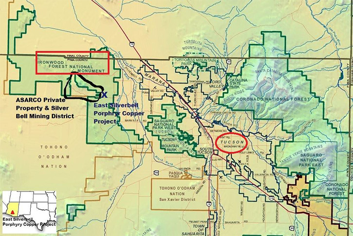
The history of the West Silverbell (WSB) and ESB started in 1966 when I was doing geomapping in the North
Silverbell Mtns, on my weekends and noticed that there was a 3.5-mile fault offset to the S, between the
West and North Silverbell Mtns. At the time I thought it was interesting but not important but looking
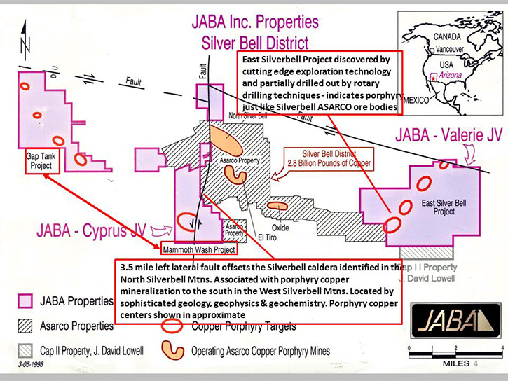
about 20 years into the future it became very critical. This was long before the founding of JABA (US)
Inc. or Liberty Star. Liberty Star has an option from JABA (US) Inc., an Arizona Corporation owned by
myself, Dr. John Guilbert [LBSR board member & technical advisor] and others, holding unpatented BLM lode
mining claims within the IFNM, initially staked years before the 2000 presidential decree by President
Clinton declaring the formation of the national monument. We have not been able to continue exploration
nor develop our East Silverbell Porphyry Copper Project, which is a continuation of the Silverbell
alteration zone and ore bodies which lie on the eastern edge of the Silverbell Caldera. The caldera was
identified by Dr. David Sawyer [1987] and described in his UC Santa Barbra PhD dissertation.
Our project, known and projected alteration, is about 25 miles long and 5 miles
wide (125 sq. miles). It is along the fault disrupted south margin of the Silverbell caldera. I think I
know where the north half of the circular caldera is but more study will be required to confirm my idea.
We are interested now in the shallowly buried remainder of the south half.
The porphyry copper ore bodies currently mined by ASARCO start at the northwest exposed end of the west
edge of the Caldera and continue easterly to the El Tiro open pit, then further east to the Wild Hog
Butte open pit, which joins the Oxide pit and the East Oxide pit and then the alteration continues under
cover to the east edge of the ASARCO property where intense alteration and breccia pipes occur at the old
Cocio Ranch. This is a distance of about nine miles.
From the early 1990s, I and Dr. Guilbert collaborated and found that our information suggested that
mineralization of the known Silverbell mining district extended to both the west of the known Silverbell
district in excess of 10 miles and to the east about eight miles. Based on those geologic projections we
formed JABA Inc., a Canadian publicly traded company, and undertook, with great secrecy, one of the
largest geochemical and geologic searches, at that time, combining existing high-resolution color aerial
photography, available aero magnetics, available IP geophysics, detailed ground magnetics over one target
in the east area along with soil, rock, and vegetation geochem.
These studies were gathered well BEFORE the creation of the IFNM. The monument overrode and was
illegally, we believe, superimposed on the lode mining claims we had on the land, which completely
ignored the productive exploration and discovery we conducted. Our research, including drilling,
indicated the intersection of an enriched (chalcocite) blanket, typical of the Silverbell district. After
the monument overlapped our valid lode mining claims (an unconstitutional “taking” with no reimbursement)
making it “illegal” to work our own claims, the critical information was secured in the JABA (US)
archives. The Canadian public company was reorganized after losing its prime target at Silverbell and the
data was returned to the new Arizona incorporated JABA (US) Inc. JABA (US) has continued to pay yearly
assessment on the valid claims. JABA (US) Inc. subsequently optioned the claims (and other projects in
the western US) in their entirety to Liberty Star in the hopes that someday this false – junk science
National Monument would be obliterated.
We move one step closer with the review by Secretary of the Interior, Ryan Zinke.
Question: Do you have an idea about the value of this project?
Briscoe: Recent very good compilation of past metal production spanning 130 years of the
Silverbell Mining District (David Briggs, spring 2017) allow comparison of the value per porphyry center
now known from discoveries from the J.H. Courtright/K. Richard exploration geology team. These allow a
projection of what might be drilled out from the Briscoe-Guilbert-Smith JABA Inc. (Liberty Star)
discoveries using cutting edge exploration technology. Thus, it is estimated that the Briscoe team
anomalies shown on the following maps in general terms total $80B in potential mineral value of copper,
molybdenum, silver, lead, zinc, gold and other metals that with new location techniques might be
byproducts or co-products within these geochemically indicated targets of the Silverbell Porphyry Copper
Project. However, all mining projects have spin off monies from jobs, services, and infrastructure needs,
resulting in well-known multiplier factors. For large metal mines, this factor is a 7x multiplier. Thus,
for mine economic production of $80 billion X 7 then a lifetime cash flow to surrounding communities of
$560 billion over the lifetime of projected mines results.
It is quite likely that additional mineral discovery using similar methods that we applied here or even
better techniques with better technology in future years, within the boundaries of what is the Ironwood
withdrawal area.
Question: Tell us more about the method and findings at East Silverbell.
Briscoe: Results of the drilling suggest an enriched copper blanket (chalcocite) as makes economic
ore at the nearby Silverbell productive mines, and new mining methods suggest potential to produce from
this mineral body. More diamond drilling will have to be done and there are probably other mineral bodies
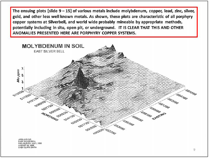
along trend that is a characteristic of the Silverbell caldera zone. In fact, our very clear geochemical
and geologic data show there may be some twelve or more copper- moly porphyry copper mineral bodies along
the extended edge of the caldera lying under alluvial cover, to the east and the west. Development of
these mineral deposits would be monumental for Liberty Star and surrounding counties and cities.
While this vital data was gathered by JABA (US) at a cost of several million dollars, the East Silverbell
claims have been wholly optioned to Liberty Star so the work can continue at only the cost of land and
work until production.
Let’s go back to the drilling days, pre- imposition of the IFNM. In about 1994, myself and Dr. John M.
Guilbert putting our heads and private data together realized that because of a fault the northern end of
the ASARCO four mine zone its nearby four open-pit mine operation at the Silver Bell Mine complex, had
been offset 3.5 miles to the south so that it was probable that the Silverbell zone continued under soil
cover on the south flank of the West Silverbell mountains. We then formed JABA Inc. a public Canadian
company and undertook, one of the largest geochemical exploration programs in North America at the time
according to Shea Clark Smith, a noted geochemist we worked with on the campaign. Additionally, the same
type of surveys were conducted to the east end of the ASARCO patented property on the East Silverbell
Project as it was called. To the east we used soil sampling, airborne detailed magnetics and very
detailed magnetics. A well-known geophysicist looked at the ground mag and pointed out a magnetic low
(characteristic of intense alteration in granitic rock) and said, “there’s your porphyry copper.”
We followed up with additional detail and formed a joint venture with a Canadian company [which
contemplated a drilling program but not with diamond core drilling as is the tried and true method, but
they insisted on air rotary drilling “to save money” This was a major error]!!
Rotary drilling has application in certain types of exploration drilling [I believe I was one of the
first to use it in the Silver Bell open pits in 1966 and 1967], it has definite drawbacks which are 1.
loss of sample into the wall rock when the wall rock is porous. 2. grinding up the ore metal when it is
soft and subject to being crushed [“pulverulent:” crumbles to dust or powder]; the copper ore rock
including chalcocite Cu2S 80% Cu (enrichment blankets) and disseminated chalcopyrite CuFeS2 (60% Cu) do
this when drilled with an air rotary hammer or with air or mud tri-cone bit. This is what happened. From
the records I reviewed recently, it appears very likely much of the sample was lost in porous basaltic
overlying lava flows or porous leached capping. When I was on site when the drill hit the water table at
a shallow level (250 feet) the water coming out of the hole
ran blood red from chalcocite (hematinic– iron oxide) leached capping – just like similar diamond drill
holes I had drilled in the Oxide, El Tiro and North Silverbell open pit areas.
Drill logs show molybdenum and enriched copper in blanket form but re-leached and mobilized to a lower
level. Where copper was assayed at up to 500 ppm there was no indication these samples were assayed by
other than geochemical analysis to see how high the assays might have been.
My observations: The geologist in charge was not competent to log porphyry copper drill holes in this
environment. Errors:
1. Chose wrong type of drill. To save money? Penny wise & pound foolish.
a. Lost all fines? either as mud after intersecting the water table or blowing fines back
into the formation or both.
b. Fines in places more than 50% of the cuttings and sometimes 100%
c. Should have chosen a diamond core drill of HQ or NQ size.
2. Poor research and drill cutting logging.
a. Did not study very fine geologic maps of the immediate area and the rest of the North
Silverbell Mountains by Dr. Barry Watson in 1965 and again by Dr. David Sawyer again in 1988 wherein a
caldera (the Silverbell Caldera) was available but no study or awareness of rock type that was expected
to be intersected.
i. No common nomenclature was used.
ii. Misidentification of rock types was rampant as no study of alteration of ore
bearing rocks was made even though such was available.
iii. Failure to identify overlying post mineral surface rock was probably
raveling down the hole from loose pumice beds at the bottom of the volcanic paleo soil interface on top
of live limonite rock. This is common with rotary drilling that hammers and slaps the side of the hole
dislodging unstable material.
iv. Misnaming existing rock type using names and typology that was simply
inaccurate confusing interpretation and meaning of the drilling.
b. Dilution of rock or loosing ore minerals by pulverization the pulverulent ore mineral
thus lowering the apparent grade of drill cuttings coming out of the hole.
3. This meant misinterpretation of the whole project and improperly rejecting it.
Despite this first round of mismanagement, JABA went on to explore and discover facts that made the East
Silverbell Project where we wanted to continue working. The information we gathered during that era
remains compelling and begs for more attention, hence we have continued to pay the claims locked within
the Ironwood Forest.
Question: Jim, what is your expectation for the East Silverbell Porphyry Copper Project going
forward?
Briscoe: We hope Secretary of the Interior Zinke recommends repeal of the Clinton era decree, so
we can go about continuing exploring the area. I’ve personally received encouragement from local business
interests and have communicated with ASARCO in the past about developing the ESB area.
Further, I believe that public comment will have a positive outcome and lead to greater value for LBSR
shareholders when we can return to the East Silverbell Porphyry Copper Project. The time is short, visit
libertystaruranium.com and follow the link to the US government comment webpage.
• Find out more about Professor John Guilbert and Liberty Star Founder/CEO/Chief Geologist on our
website: About Us
• View the ESB Infographic on our website: Projects
|
|